This product is a must-have for any postcard collector or travel enthusiast. It's perfect for those who love collecting unique souvenirs from their travels or simply enjoy sending thoughtful messages to loved ones far away. Imagine receiving one of these gorgeous cards in your mailbox! It would be like taking a mini-vacation to Canada without ever leaving home.
One great way to use these postcards is by writing about imaginary trips around Canada based on each picture featured on them. You can also share interesting facts about each location depicted on the cards as well as personal experiences related to those places visited before. When exchanging postcards between people all over the world, we create human-to-human connections that make us feel closer despite being miles apart physically speaking. Sharing stories and memories via mail creates bonds that transcend borders, making our planet seem smaller than what it actually seems at times.
To get started using these amazing pieces, here are a few tips: write a personal message on the back of each card, sharing your thoughts and feelings about the image or location depicted. Address them to friends, family members, or even strangers who share similar interests in travel and postcard collecting. You can also use online platforms like Postcrossing.com for exchanging cards with people from all over the world. Use these as inspiration for planning future trips around Canada.
The design of this pack is simply stunning! The images are high-quality photographs that capture the beauty of Nunavut perfectly. Each picture has its own unique charm and tells a story about the Canadian territories. The pack includes five postcards, each with a different image: Mount Thor in Auyuittuq National Park, beluga whales swimming in icy waters, frozen tundra and snow-covered mountains, traditional Inuit tents against an Arctic landscape, and two arctic foxes playing together.
15x10.5 cm
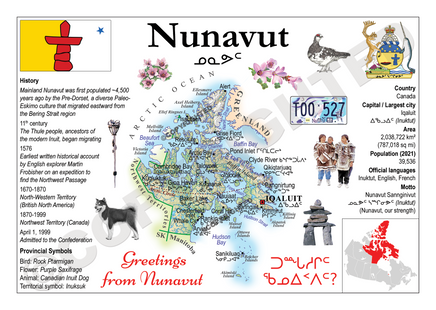
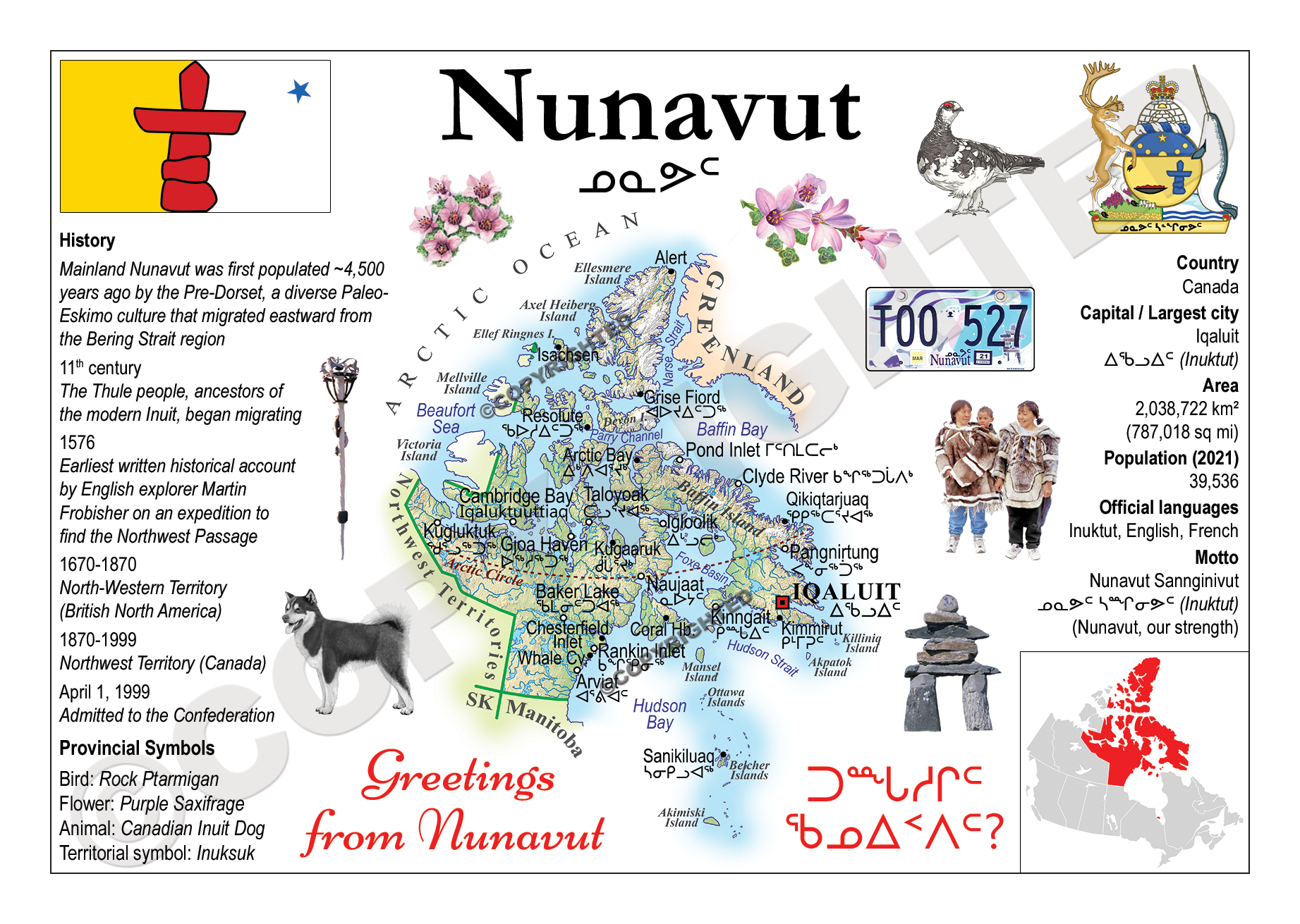
Glossy chromo Hi-Quality paper - Nunavut map and info about.
Nunavut is the largest and northernmost territory of Canada. It was separated officially from the Northwest Territories on April 1, 1999, via the Nunavut Act and the Nunavut Land Claims Agreement Act, which provided this territory to the Inuit for independent government. The boundaries had been drawn in 1993. The creation of Nunavut resulted in the first major change to Canada's political map since the province of Newfoundland was incorporated in 1949.
Limited Time Only
This item is NOT available in stores.
Guaranteed safe checkout:
PAYPAL | VISA | MASTERCARD
Click BUY IT NOW To Order Yours!